Saint Vincent
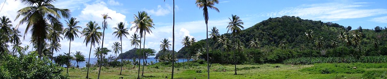
A gorgeous group of islands unspoiled and waiting to welcome you…. St. Vincent is the largest island, with a mountainous, heavily cultivated interior and a rugged coastline dotted with beautiful black and white sand beaches.
The Grenadines, 32 islands and cays, offer white coral sand beaches and crystal clear waters for snorkeling, sailing and diving. The main islands of the Grenadines are Bequia, Canouan, Mustique, Palm Island, Petite St. Vincent, Mayreau and Union Island and Palm Island. St. Vincent has an area of 133 square miles – 18 miles long and 11 miles wide.
The Grenadines have an area of 17 square miles. Together they have a population of 107,598.The waters around Saint Vincent and The Grenadines are crystal clear and warm throughout the year. With many dive sites, each with its own name and unique and amazing characteristics.
Saint Vincent and The Grenadines diving, snorkeling, fishing and adventure are the highlights of this tropical paradise…in Saint Vincent and The Grenadines. Saint Vincent and The Grenadines divers from all over enjoy the azure waters that surround the island.
Just a mile or so from E.T. Joshua Airport is the bright and bustling capital – Kingstown. Every week, huge cargo ships dock at the jetty to load the islands’ main export – bananas – for the long journey to Europe. Kingstown market – a real Caribbean market – where you can choose from many varieties of fruits and vegetables: mangos, oranges, lemons, tangerines, pineapples, bananas, breadfruit and more are on offer.
The Kingstown fish market – recently built – will also excite you with its range of kingfish, snapper and grouper. In the northern part of town, visit the historic Botanic Gardens – the oldest in the Americas. Here you will find offspring of Captain Bligh’s original breadfruit tree, alongside a species of plant and parrot unique to St. Vincent.
Just outside Kingstown, at over 600 feet, is Fort Charlotte, completed by the British in 1806 during their struggle with the French and the Caribs for control of the island. Original canons still wait for action on the battlement and the barracks have been converted into a pictorial museum illustrating the island’s colorful history. It is easy to transport yourself back to the last century and to appreciate then location of the Fort, with a commanding view over the sea and the whole south of St. Vincent.
A coastguard lookout post puts this view to good use to this day. On a clear day, you can see as far as Grenada, some 60 miles to the south. Looking north, enjoy the views of the west coast and Mount St. Andrews, the southernmost of the peaks, which form the backbone of St. Vincent. The duty watchman will be pleased to let you use his powerful binoculars to view far off yachts.
St. Vincent is divided into two distinct coastal structures Windward (east) and Leeward (west). The Leeward (west) is endowed with a series of spectacular slopes and valleys running down into tranquil waters and beaches such as Ottley Hall, Mount Wynne and Kearton’s Bay. One of the valleys, Buccament, also boasts a casino and a nature trail. The trail is ideal for picnics and for a sight of the elusive St. Vincent parrot. The drive up the meandering Leeward highway takes you through the villages of Layou and Barrouallie to Chateaubelair and Richmond, where the road
ends with the sea on your left and mountains with the Soufriere Volcano in sight.
At the northwestern tip of the island are the breathtaking Falls of Baleine, only accessible by boat but an experience not to be missed. Fresh mountain water plunges 60 feet into a natural pool, before running down towards the sea. Standing beneath the Falls is pure exhilaration. A long way to go for a shower but well worth it. The Windward coast is equally rewarding but very different from the Leeward side. Here you will be immediately aware of the contrast by the roaring sounds of the Atlantic waves, which rush unceasingly onto rugged cliffs and beaches formed by volcanic
lava. Amidst all of this is the refreshing smell of the sea brought in by the trade winds, which constantly fan the shoreline.
The Windward Highway heads northwards along the coast, through some of St. Vincent’s most fertile agricultural lands, to Georgetown, once the centre for sugar production and still the source of Vincentian rum. North of Georgetown, a four-wheel drive vehicle is advisable for crossing Rabacca Dry River onto the Orange Hill Estate. Once a major coconut plantation of over 3,000 acres, it is now being resettled by small farmers under a government rural project.
Once across the Dry River, you can continue north to Sandy Bay, Owia and Fancy, the northernmost settlement in St. Vincent. Stop off at the Owia Salt Ponds, a popular site with a good view of St. Lucia 20 miles to the northwest.
Heading inland from the Dry River is a trail climbing through the rain forest to the crater of La Soufriere, St. Vincent’s volcano. It is an arduous hike, best started early in the morning, but the view into the crater is ample reward.
