Niagra Peninsula
The peninsula, lying between Lake Ontario and Lake Erie and separated from the state of New York by the Niagara River, is one of the most visited and probably the best known tourist regions in Canada. Only a few days should be spent in the area, as the landscape is not nearly as attractive as in other parts of Ontario. Three bridges conntect the Canadian town of Niagara Falls with the American town bearing the same name. Rainbow Bridge provides a particularly beautiful view of the falls. As for the lookout towers (Skylon, Minolta Tower) on the Canadian side, they are open round the clock.
White settlement in the region began in the 1770’s in response to the American Revolution. Hundreds of Americans loyal to the British crown sought refuge in the area. While wives and children were deposited in Fort Niagara, which lay on the American side of the Niagara River, the men joined the army. In time, a fort, Butler’s Barracks, went up on the Ontario side, and soon farms for refugee families were built along this western bank of the river. Settlement then extended west after an agreement was made with the local Mississauga Indians. All the main attractions in this region lie along the eastern shoreline of the Niagara River. If these attractions are all you care to see, and you’re coming from Toronto, simply get on the Gardiner Expressway West at the downtown’s southern base. This highway becomes the QEW and will take you all the way around Lake Ontario’s semicircular western shoreline to Hwy 55, which provides a short route north to Niagara-on-the-Lake. You will be able to see the flat, pastoral landscape of the region, if you get off the QEW in Hamilton and onto Hwy 8 and then Route 81 both traveling east. The 81 is part of what is called the “wine and vineyard route,” a path through 16 wineries and juice plants running from the western border of Niagara County to the Falls. Most of these businesses are open daily.
Other worthwhile destinations off of 81 while heading east: at the city of Grimsby take Route 12 south to Beamer Memorial Conservation Area, which takes in a stretch of the Bruce Trail; further east at Ball’s Falls take Rd. 24 south and another conservation area can be found, this one with two waterfalls at its Twenty Mile Creek; at the city of St. Catherines take Route 34 north to Route 87, past orchards and vineyards, all the way to Niagara-on-the-Lake.
With its idyllic setting on Lake Ontario, near the northern mouth of the Niagara River, and its well preserved 19th century architecture, Niagara-on-the-Lake is one of the most delightful towns in Canada. It was the capital of Upper Canada in the 1790s, but was called Newark then. The main strip is Queen Street. An excellent attempt has been made here to recapture the (imagined?) leisure, elegance and prosperity of an earlier time. An apothecary built in 1886 has been restored. Oldstyle bakeries and fudge and jam shops provide tasty treats. A clock tower honors the dead of World War One. And the centerpiece of the street, an old Victorian hotel, the Prince of Wales, offers elegant accommodation. The Shaw Festival, honoring the Irish playwright George Bernard Shaw is an attraction from mid April to the end of October. Outside of town are two interesting sights. On Hwy. 55 is a perfume factory and museum showing how the “smells” used to be produced. If you like dolls, visit the Mahoney Doll’s House Gallery on Niagara Road. Fort George National Historic Park (mid-May to October), on the edge of town on the Niagara Parkway, is also worth visiting. It is a reconstruction of the twice-destroyed fort which British forces used to defend against the Americans following their revolution.
Winston Churchill once called the Niagara Parkway “the prettiest Sunday afternoon drive in the world.” The Parkway runs south from Niagara-on-the Lake all the way along the full length of the Niagara River to its southern estuary at Fort Erie.
The American state of New York is just to the east across the river. And throughout the 40-minute drive there is a splendid view of a hilly river bank, which grows into a deep limestone chasm the closer the Falls get.
Take the parkway into Queenston and follow the signs to Queenston Heights. At the top of a towering hill is a magnificent statue of General Isaac Brock, who died while leading his troops to victory in a battle here against the Americans during the War of 1812. The monument (which can be climbed for a good look around the area) is decidedly un-Canadian, both in its grandeur and its cockiness: General Brock faces New York State across the Niagara River a top of column many feet above the ground. He appears to be taunting the Americans with his outstretched arm.
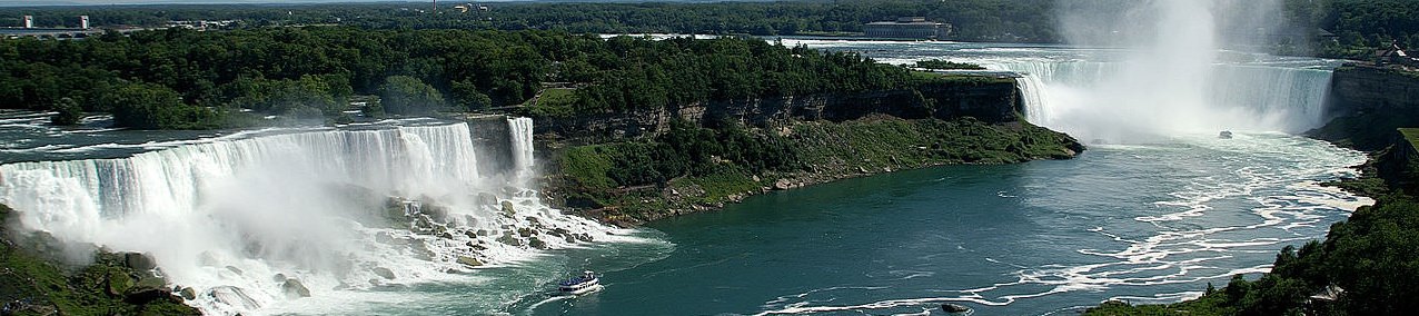
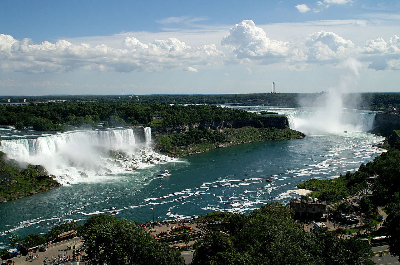
The world-famous Niagara Falls are next on the route. The Parkway travels right beside them and, if you follow the signs, parking is readily available. Of the American Falls and Horshoe Falls, it is the Horseshoe on the Canadian side that are the most spectacular. Even the most reluctant tourist can not help but be awed by the 34 million gallons of water that crash by the minute over this 54-meter (173-ft) limestone wall. But the most exhilarating way to experience the falls is to ride the Maid of the Mist Steamboat (5920 River Rd.) through the turbulent waters lying just beyond the plummeting torrents. Hooded raincoats are provided for good reason.
Fort Erie, 18 mi (29 km) south, completes the Parkway drive. The fort here, which the city is named after, hasn’t so much an exciting military history as a history of inclement weather, having been leveled twice by storms. The American army also torched it once, in the year 1813. The reconstructed version, sporting a moat, a drawbridge and cannons, strikes an impressive figure especially with the drills in authentic uniforms. Inside it houses equipment from British and American armies.
If making your way back to Toronto take Hwy 3 west, turn right on Route 58 north until you hit Hwy 20. Turn left or west and travel the highway’s scenic flat, farmland route until you are through Hamilton and back on the QEW again. One possibility is visiting one of the beaches just south of Route 3 along Lake Erie’s northern coastline. Crystal Beach, not far west of Fort Erie, is a popular resort, and, if you have children with you, offers a large amusement park.
A word is necessary about southwestern Ontario. With apologies to those who live in and, no doubt, love this region of the province, it is not easy to recommend it as a vacation area. Encompassing 15 counties south of Grey-Bruce and west of the Niagara Peninsula, it offers neither the natural beauty, the rural charm, nor the historical interest of so many of the other regions in Ontario. And though it does certainly boast interesting attractions, its area is so great, that the driving involved would be prohibitive: Nonstop it would take ten hours to round the coastline from Selkirk Provincial Park, south of Hamilton, to Point Clark, at Bruce County’s southwestern edge.

